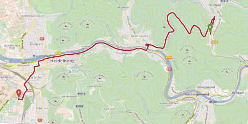
Openrouteservice's directions can be used all around the globe. Consume rich route instructions in your applications for cars, trucks, different bike profiles, walking, hiking or wheelchair. Make use of plenty of options, ranging from different kinds of road restrictions to vehicle dimensions.
Reachability has become a crucial component for many businesses from all different kinds of domains. To this end, you can use openrouteservice to obtain isochrones which will help you determine which areas objects are able reach in given times or distances.
Matrices allow you to compute many-to-many distances and the times of routes much faster than consuming the directions api over and over again. This application is frequently used by logistics companies trying to figure out the most optimal route for deliveries.
Geocoding transforms a description of a location, such as a place name, street address or postal code, into a normalized description of the location with a point geometry. Our geocoding service is built on top of the sophisticated Pelias Stack which aggregates several data sources.
Openpoiservice allows you to find places of interest around or within given geographic coordinates. You can search for categories of points of interest around a point, path or even within a given polygon and consume the rich meta information returned by the api for your needs.
Use our Openelevationservice to easily enrich your 2D geometries with height information based on SRTM data. Pass Point or Line geometries in different formats and recieve the 3 dimensional version back within milliseconds in your preferred format.
Traveling Salesmen and other Vehicle Routing Problems are no problem for our optimization endpoint. Based on the excellent Vroom project this service provides you with optimal routes while considering your specific vehicle and time constraints.
Our classic route planning tool enables you to use most of the openrouteservice API with only a few clicks on a map. Choose from a variety of profiles and set up to 50 waypoints to plan your route. Customize it by avoiding areas, specific street types or whole countries. Query POIs along your route, perform accessibility analyses for multiple points or simply inspect locations.
These and many more amazing features are offered free of charge and in different languages. But the best thing about this: It's open source, so with a little bit of JavaScript knowledge you can easily adjust the client to your personal use case.
Based on the classic version, our client for disaster management is developed to support the work of humanitarian actors and disaster responders in the most vulnerable and disaster prone regions of the world. Thanks to the work of the Humanitarian OpenStreetMap Team and the Missing Maps project, in disaster situations the OSM data is continually updated and enriched with critical information. By limiting the service to active disaster regions, it is possible to recalculated the routing graph once every hour on basis of the most current OSM data.
Our new maps client was built with the awesome VueJs framework is already available. The new client keeps all functionalities of the previous one, but is completely responsive and optimized for usage on both mobile and desktop browsers, while brings a bunch of new features. We are aiming for a more intuitive map interface that makes route planning even easier and are putting a lot of thought in structural and performance enhancements.
Help us to improve your user experience by providing us with feedback via our ask forum.
The source code is available for everybody on GitHub. A big advantage of the new approach is the possibility to convert the client to a native mobile app with ease, which brings us closer to offering an actual live routing app. So stay tuned for future developments!
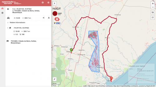
The openrouteservice directions service covers the globe and allows you to compute routes and all sorts of navigation information. To this end, we offer a wide range of travelling options for multiple modes of transport. Amongst these you can choose between car, different bicycle types, walking, hiking, wheelchair and heavy vehicle. Each of these modes uses a is a carefully compiled street network to suite the profiles requirements. To help you individualise your routes even further the API offers the possibility to customise your input with road type restrictions and vehicle characteristics.
With openrouteservice you are able to determine routes for car and heavy vehicle with distances up to 6.000 km with any kind of options added.
Openrouteservice's heavy vehicle routing option has been developed hand in hand with logistics companies to ensure realistic routes all over the globe.
The openrouteservice geocoding api accesses global databases and transforms descriptions of locations, such as place names, street addresses or postal codes, into a normalised description of the location with a point geometry. Additionally our geocoding service offers a reverse geocoding service which does exactly the opposite. It transforms the coordinate of a point into the description of the next enclosing object which surrounds the given coordinate. To obtain more relevant results you may also set a radius tolerance around the requested coordinates.
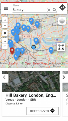
Openrouteservice's POIs api helps you find points of interest around or within given location(s). This service has a global coverage and can be used for different kinds of use cases. You may either search for a single or list of category types contained around a point, path or even within a given geofence. Furthermore you are also able to query and gather statistics featuring the amount of certain POIs in an area.
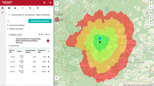
To determine reachability areas from any given location(s) on the map we offer the isochrones service which returns these regions as contours of polygons. You may specify 2 types of input, namely time or distance as well as corresponding intervals. If the input entails a list of points the service will return intersections of the computed isochrones if any exist. Within this API you are able to use the identical set of options that are found in the directions service.
A typical use case of isochrones is figuring out how far an object is able to travel within a given amount of time or distance. One may also want to find out which catchment or community areas a certain location has, e.g. schools or shopping precincts.
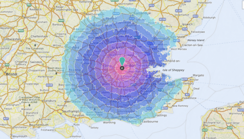
The underlying technology generating the isochrones allows you to determine huge areas with unusually high performance. Make use of multiple locations at once and let the api find intersections of isochrones for you.
To save time you can specify up to 5 locations of interest at once. And if you want to know where the isochrones intersect, simply let the API compute these for you.
One to many, many to many or many to one. Openrouteservice's time-distance matrix service allows you to obtain time and distance information between a set of locations (origins and destinations) and returns them to you in a structured JSON response. This API is extremely convenient and scalable for batch requests determining aggregated metrics of routes (it does not return detailed route information, use the directions api for this use case). Akin to locations and directions, you may specify the transportation mode and compute routes which adhere to certain restrictions, such as avoiding specific road types or object characteristics.
One prominent use case which can be built on top of this service is to easily explore the fastest or shortest combination of a set of destinations which should be reached -- this is commonly referred to as the traveling sales person problem.
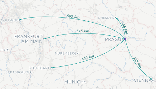
This basically means you are able to request a combination of 50 times 50 origins/destinations pairs at once. Head over to our developers overview and find out how.
We make use of state of art graph traversal algorithms to guarantee stable and performant responses.
Use our openelevationservice to transform 2-dimensional points or lines (e.g. routes or POIs) into 3-dimensional objects with height information. The elevation data is based on a SRTM (Version 4) data set with 90m x 90m resolution (at equator), that was CGIAR postprocessed to generate a seamless, complete global coverage without data voids. Request and receive geometries in three different formats: simple geometry, GeoJSON or encoded polyline.
Openrouteservice's optimization api can be used to solve various vehicle routing problems. This versatile service will not only provide fast responses but lets you customize your vehicle, task and time constraints according to your needs. By specifying multiple vehicles the result will be optimized for your whole fleet. The tasks can be either defined as jobs, which are single-location pickups or deliveries, or as shipments where pickup and delivery should happen by one vehicle on the same route. We provide a working example request in our api playground, so start optimizing right away.
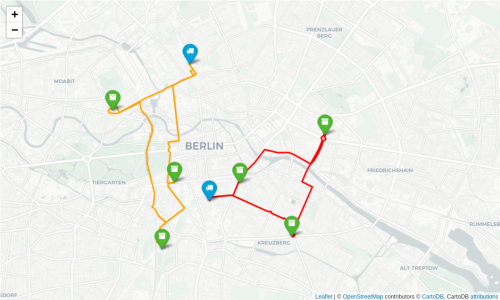
Each vehicle can have separate capacities for multiple goods to define storage limitations. Tasks (shipments and jobs) will consume or free up a vehicle's capacity.
Every task can require skills which have to be met by the vehicle handling the task. Only capable vehicles will execute the task.
Tasks can take a specified amount of time and can be executable only during a limited time window which could for example represent working hours or deadlines.
Tasks can be prioritized to specify the importance. The optimization will favour more important tasks and do them as soon as possible.